Hiking is physically demanding the best of times. Try hiking 24 km with a loaded backpack over two passes to reach the highest mountain pass in Jasper National Park, followed by another 22 km to return to your vehicle, and then mix in rain, wind, and snow. That describes the Skyline Trail hike that Michelle and I completed this fall. The reward: beautiful autumn views of the Rocky Mountains.
The Skyline Trail is a popular destination that attracts hikers from around the world. It is a challenging hike of over 46 km with 25 km above the tree line. The trail has an elevation gain of 1380 m and reaches an elevation of 2510 m. The most demanding section is the stiff climb up to The Notch, a saddle ridge where the trail is often snow-covered until late August. Most hikers complete the route in three or four days, although some finish in two days. Some even run the entire trail in one day. We completed the hike in four days.
I have done the hike twice before, most recently last year with a buddy. I wasn’t expecting to hike it again this year, but my video of the hike inspired Michelle to end her thirty-year backcountry hiking boycott and take on the challenge this year.
I started preparing for the trip a few weeks in advance by dehydrating our meals using a food dehydrator that Michelle gave me for Christmas. Dehydrated meals are ideal for backpacking because they don’t need refrigeration and reduce the weight of the backpack. Dehydrated meals are sold at stores like Mountain Equipment Coop but meals made at home are cheaper and taste better. I dehydrated mangos and apples for snacks and also made three meals that we would eat at the end of each hiking day. They would be rehydrated in a cooking pot at the campsite and then heated on my camp stove.

A couple of days before the hike, Michelle and I stood on the weigh scale with our fully packed backpacks to measure their weight. I wanted to keep Michelle’s pack under 25 lbs, and mine under 40 lbs. Michelle used my old heavy backpack, so she carried all the air mattresses, sleeping bags, and half the tent, while I carried the rest of the tent, stove, pots, fuel, and food. In the end, we both carried a few extra pounds because we needed to bring heavier clothing for a fall hike and because we borrowed a three-man tent, instead of taking my ultra-light two-man tent. My two-man tent only has one door and no vestibule to keep backpacks and hiking boots dry. There’s also no room to sit upright and dress, so we decided the three-man tent was worth the extra weight.
What I feared most about the hike was the weather, so I was constantly checking the long-range weather forecast. From experience, I know poor weather can ruin a backpacking trip, and since we were hiking late in the season, I worried it would snow. The day before the hike, the weather forecast called for showers with sunny breaks, which had me worried–showers at lower altitudes mean wind and snow at higher altitudes.
The Skyline Trail starts at Maligne Lake and finishes at the Summit Mountain parking lot. To get there, Michelle and I were on the road by 4:30 AM to catch the 9:00 AM shuttle from the Summit Mountain parking lot to Maligne Lake. Most people start the hike at Maligne Lake because it’s at a higher altitude, making it easier to reach The Notch.
There were eleven other hikers on the shuttle, with couples from California, New York City, and Toronto, and the rest from Alberta. Michelle and I were by far the oldest couple. Everyone talked with excitement and was impatient to get the trek started. A topic of conservation was finding where the other hikers reserved campsites. Michelle and I reserved Snowbowl, Curator, and Signal campsites for our trip. The young couple from Toronto found out they reserved the wrong campsite the second night and changed their reservation while on the shuttle. They were lucky to change reservations because campsites get fully booked when reservations open on March 1, so someone made a last-minute cancellation.
During the shuttle ride, I nervously peered out the window to check the weather at the higher elevations. Fortunately, there were patches of blue sky and white clouds and it hadn’t snowed. The weather was better than I expected when we left Edmonton that morning.
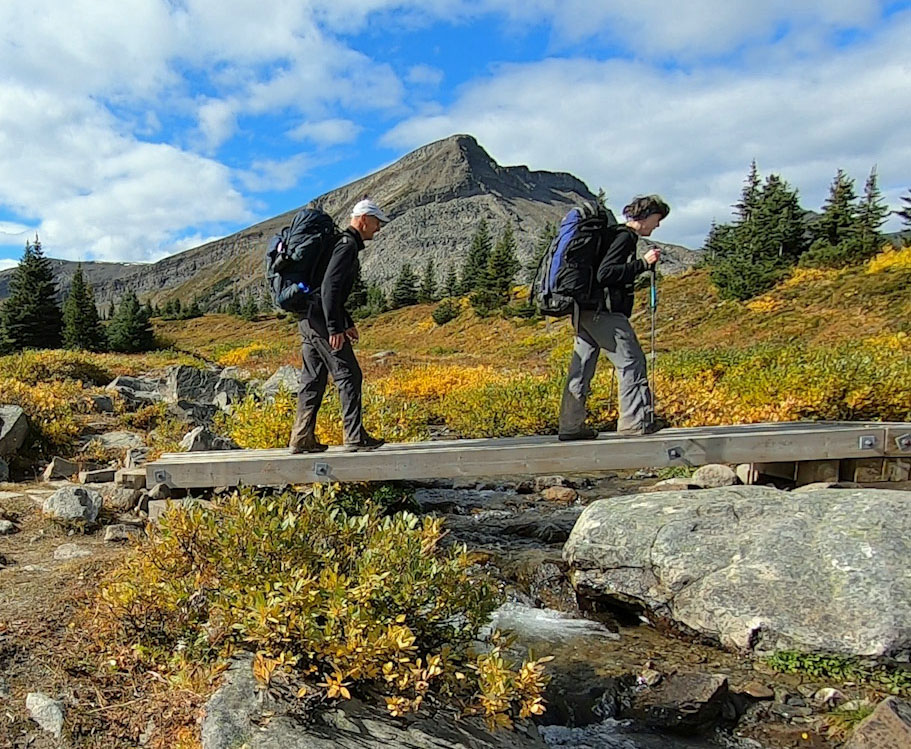
At Maligne Lake, the driver let us off and jokingly pointed to Skyline Trail and said we’d find our vehicles at other the end. Michelle and I collected our packs and began our 12 km hike to the Snowbowl campsite. We started out with the young couple from Toronto whose only experience backpacking was touring through Europe. They had borrowed all their equipment from friends in Calgary, and when I looked at their packs, I had my doubts whether they had enough experience to complete the hike. They had cheap blue foam sleeping mattresses to insulate them from the cold hard ground and extra gear hanging outside their pack. Adding more gear to the outside of the pack adds extra weight, and soon they were struggling to keep up. Michelle and I hiked ahead to Little Shovel campsite and stopped for lunch, and when they arrived, they visited with us some more. They were eager to learn from our experience and asked many questions about the trail and bear safety. While answering their questions, I became disturbed because they had little knowledge of backpacking and the difficulty of the Skyline Trail. They had reserved Little Shovel that night, so they had finished their day’s hike. Michelle and I said goodbye and told them that we looked forward to seeing them the next night at the Curator campsite.

The last four kilometers of our hike to the Snowbowl campsite were not pleasant. A storm suddenly developed, and we didn’t have time to put on our rain gear. One moment it was sunny, and the next we were being pelted by driving rain and snow. To make matters worse, we still hadn’t descended a steep rocky embankment. Earlier, I had warned Michelle that this section was going to be difficult, and when we arrived, the rain made the descent slippery and even more treacherous. We had to use our poles for extra stability and cautiously work our way down the embankment. At one location, Michelle slid down on her butt to make sure she didn’t slip and fall to the bottom.
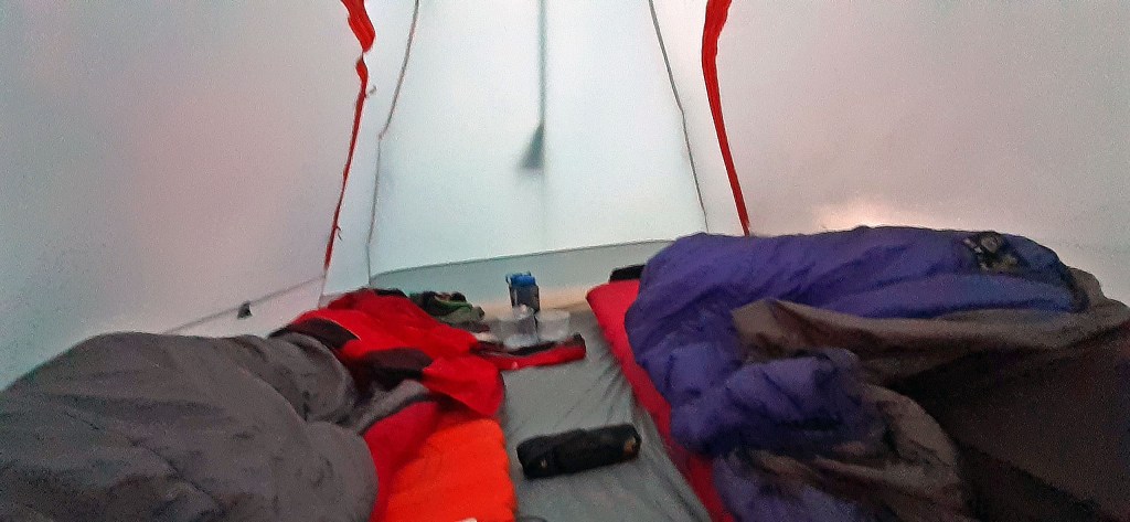
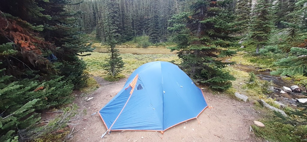
When we arrived at our campsite, our pants were wet and muddy, but the sun had returned and we could set up camp and dry off. We dined on Spaghetti Bolognese and, after cleaning up, placed our food and cooking gear in the bear locker and retired to our tent to read and relax. The campsite had ten camping spots; at the end of the day, they all were occupied.
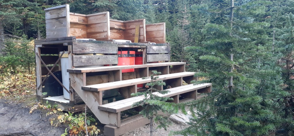
At Snowbowl, Michelle was shocked when she looked at the toilet facilities. We have camped in the wilderness many times during our canoeing trips, and she has adjusted to the complete lack of amenities. However, to her, the arrangement at the backpacking sites was worse. They built toilets high on a platform and out in the open so that helicopters can lift the large container full of sewage and dump it at a treatment facility; a much more environmental practice than traditional enclosed outhouses. The view of the Rocky Mountains is amazing, but there’s no privacy. The most disconcerting part for Michelle was the platform had three toilet seats. I explained to her the toilet design reduced the number of trips helicopters fly, and was not designed to allow three hikers to use at once.
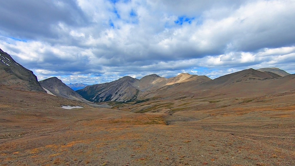
The next morning it was biting cold, but it turned out to be an exceptional day to climb Big Shovel Pass. It was sunny the whole day, and it warmed up as the day progressed. With the sun shining, the fall colors were on full display. We stopped for lunch before hiking the pass and enjoyed the vivid colors of the subalpine valley one last time.
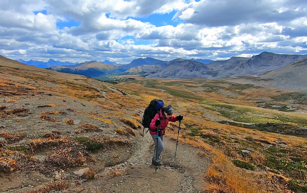
The hike up to Big Shovel Pass is tough. It’s the second-highest elevation reached on the trip, and it is here the alpine region of the hike starts. When we reached the top, The Notch was looming at the end of an alpine valley. It is an intimidating sight: another 250 m higher with a steep slope composed of small loose stones (scree) and larger rocks (talus). There was also snow on the precipice of the mountain (cornice). As I contemplated the next day’s stiff climb, I hoped for pleasant weather.
After we arrived at Big Shovel Pass, it was a long descent to the Curator campsite. We arrived fatigued, having hiked 23 kilometers and climbed two passes over the past two days. When we arrived, we did not expect to see the campsite empty. That was worrisome because we hadn’t heard a weather report since the morning we left Edmonton; was there stormy weather moving in that had caused others to turn back? The next day we had to climb The Notch, and getting caught in a storm at that altitude is not a risk worth taking. We also had 17 km to our next campsite. After considering our options, we decided to hike at sunrise to allow us enough time to finish the day’s hike, but if The Notch looked impassable, we’d take the emergency exit—the 15 km Wabasso Trail to the Icefields Parkway — and call a cab to get to our vehicle.
We set up camp and watched for the couple from Toronto, but they never arrived. We don’t know what happened to them; hopefully, nothing harmful occurred, and they just decided the hike was too difficult. Eventually, a single hiker we named Mountain Man arrived. He was obviously fit and an experienced hiker, having hiked the entire distance that day. He told us that the weather report was promising: it called for sun in the morning and rain in the afternoon. That was encouraging news; we just needed to be off the mountain before the rain started.
That evening we dined on Sheppard’s Pie and then crawled into our sleeping bags for an early night, setting our alarm clock for 6:00 AM. I went to sleep thinking about the difficulty of the next day’s climb up to The Notch, and the long arduous hike to Signal Campground. I didn’t relish the idea of hiking in the rain, but if we made it to The Notch with blue skies, I’d be ecstatic.
….. to be continued.
https://deansblogthebestisyettobe.wordpress.com/2021/11/16/the-notch-part-ii/

Excellent 👍
LikeLike
Nice post! The “throne” at least saved you from having to balance over a hole in the dirt. Or, having to use a wag bag like I did in full view on the Mount Whitney trek in August.
Great photos too. Best wishes.
LikeLike
Hello Reg. Thanks for reading about our experience. Good for you for being able to do a hike where you also have to carry your poop out. Fortunately, there are no hikes like that in the Rockies. At least, none that I know of. Thanks for the kudos. Take care. Dean.
LikeLiked by 1 person
I love thinking about doing this hike. We backpacked Jasper 1993 and fell in love with the area, well we actually love all of Canada. I am keeping this hike on my radar. Might go when weather is a bit warmer. Snowed at Maligne Lake in July the year we were there. 😄. Thanks for sharing. Hope we are not too old yet and that we are still able to cross the border next couple of years!
LikeLike
Hello Barb. Thanks for reading about our experience. I hope you get a chance to come back to Canada and hike the Skyline. Our governments are talking so I expect the border will be opening some time this year. If you do get here, stay and do some of the other hikes in our National Parks. Skyline is the most popular, but there other hikes that are just as spectacular. My other favorite hike in Jasper National Park is to Jonas Shoulder.
LikeLike
I am back with another comment after reading more of your blog. Have you considered writing a book? I have sure enjoyed writing both of mine and it is great fun to hear from readers/fellow trekkers. You may have heard about Amazon KDP publishing. That has been my vehicle; it is free and the KDP website has tutorials. Let me know if you have questions.
Best regards,
Reg
LikeLiked by 1 person
No, but thanks for the encouragement!
LikeLike